
When the Congress ended on Saturday around noon, one of the participants who had a plane leaving in the evening, asked about a ride and going hiking. So we agreed to head to Pemberton and walk along this trail by a green colored river. Very warm in this area .and a fun hike after many days in doors!

Jane Agerter Lacy, a fellow Faribault class of 1965 grad and I have been in conversation off and on recently. Our parents knew each other from their mutual connection to Shattuck School and the Cathedral. In fact the two families owned property on the Straight River together and the parents built a shack on the prop, as they called it in the early 1940's, Ken and Peggy Agerter and Pete and Peg Weaver shared a lot of activities as my mom, wrote in her memoir.
I left Jane and Al's Place in Issaquah, outside of Seattle around noon on Sunday, and visited a friend Harv Brenneise on Capital Hill in Seattle and had Pho in the neighborhood. Seattle seems like such a much bigger city than when I last visited 20 years ago. Busy with freeways, and quite a hot summer!
So I headed south to see what Portland might be like, and was quite warm as I drove by Battle Ground and Vancouver. A friend in Portland was not available to see me, so I made the decision after a good meal on the island in the middle of the Columbia River, and talking with Ernie and Margaret Campbell, that going up the Columbia Gorge, on a Sunday evening was the best fit! I found a motel in my price range in Hood River, and took the scenic route part of the time on old US 30, past Bridal Vail and other falls on the south side of the river.
http://www.historicthedalles.org/columbia_gorge_waterfalls.htm

Dry looking fields above the Columbia on scenic US 30.

Dry fields again along the scenic route.

Columbia River from an overlook. Smoke in the air from the Rowena Fire.
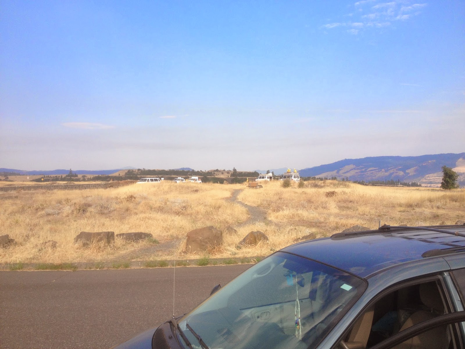
White fire fighter vehicles at a pull over view point above Rowena, with my pony in front.

At one point on the trip here above the town of Rowena on scenic US 30, I could see plumes of smoke. I was here on Aug 11, and the fire fighters here on the overlook, now were in "mop up" phase.
Here is what was going on a couple of days before "
ROWENA, Ore. (AP) — A wildfire in the Columbia Gorge is threatening
homes in the community of Rowena, between Mosier and The Dalles."
http://www.statesmanjournal.com/story/news/2014/08/06/columbia-gorge-wildfire-rowena/13668955/

Monday Aug 11. Well, finding my lodging in Hood River got me there in an easy does it manner. Safely through the fires of the day, and great scenery of the Columbia Gorge. Just down the street I found a nice cafe that served me a latte' to wake up. I decided on a local omlet with potatoes, as I had learned the town is also noted for cherries. I simply asked for one pancake on the side, and OMG, this is what they served. American oversized portions! Nice cherries, and I took the two cakes to Walla Walla, when Ernie Campbell and I could share for breakfast on Monday AM

Hood River omlet with a "side of a cherry pancake " :-)
 For many years I have purchased Pendleton Blankets for give aways and well as factory seconds from the Faribault Blanket Mill in my home town. Well, here is the Woolen Mill in Pendleton where many of the trade blankets have been made for years, with my HRC Equal Rights Magnesium Pony parked outside.
One of the photos of the history of trade in the Pendelton Area on the wall .

http://prairielakesjourneystwospirit.blogspot.com/2014/08/1967-photos-bwca-faribault-episcopal.html
And then mine as well
rairielakesjourneystwospirit.blogspot.com/2014/08/1967-faribault-cathedral-youth-bwca.html

Margaret and Ernie Campbell who moved from Faribault to Walla Walla in 1969. Ernie was the priest at the local Episcopal Church most of their time here.


My goal on Tuesday was to make it into Montana past Missoula, and I noticed a lot of the history here, the Nez Perce horses of the tribe made famous by Chief Joseph.


Donate here, early and often. :-)
http://www.conservemontana.org/content/craighead-institute/cnm3E8DD645444A64B22

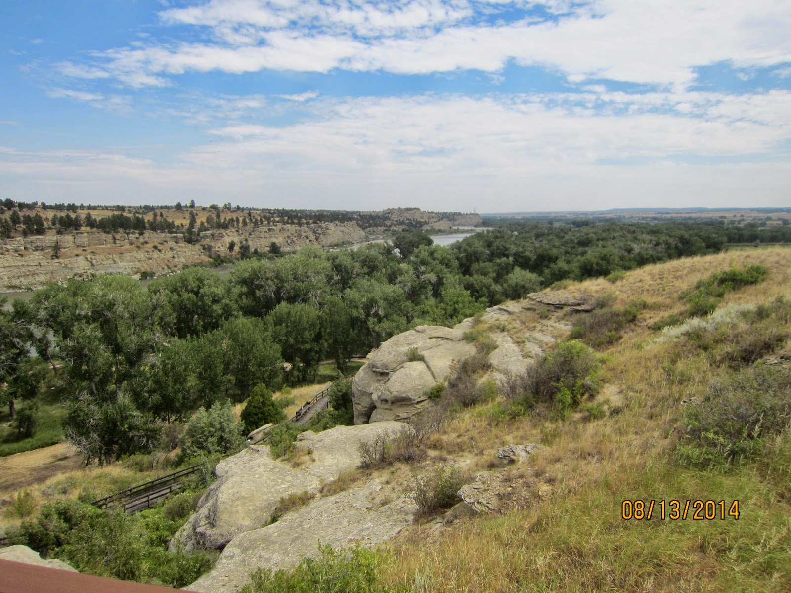
From Wiki " Pompeys Pillar National Monument is a rock formation located in south central Montana, United States. Designated a National Monument on January 17, 2001, and managed by the U.S. Bureau of Land Management, it consists of only 51 acres (21 ha), making it one of the smallest National Monuments in the U.S. It was previously designated a National Historic Landmark on July 25, 1965.[2] The new Pompeys Pillar Interpretive Center opened in 2006. Exhibits in the 5,700-square foot center relate the journey of Captain William Clark and his detachment, including Sacagawea and her son Pomp, down the Yellowstone River Valley in 1806.
The pillar itself stands 150 feet (45 m) above the Yellowstone River and consists of sandstone from the late Cretaceous Hell Creek Formation, 75 – 66 million years ago. The base of the pillar is approximately 1 acre (0.4 ha).
The pillar features an abundance of Native American petroglyphs, as well as the signature of William Clark, co-leader of the Lewis and Clark Expedition. Clark's inscription is the only remaining physical evidence found along the route that was followed by the expedition.
The inscription consists of his signature and the date, July 25, 1806. Clark wrote that he climbed the sandstone pillar and "had a most extensive view in every direction on the Northerly Side of the river". He named the outcropping after Jean Baptiste Charbonneau—the son of expedition member Sacagawea—whom he nicknamed "Pompy". His original name for it was "Pompys Tower"; it was changed to the current title in 1814.


No comments:
Post a Comment